Ward 4 residents and bicycle riders of all stripes have been waiting for the District Department of Transportation (DDOT) to complete a missing segment the Metropolitan Branch Trail between Fort Totten and Eastern Avenue for more than two decades. But some residents aren’t happy with proposed designs to make the trail a wide sidewalk in some places, and an on-street route in others.

Overview of DDOT’s plan to extend the MBT to Maryland
At a recent meeting, DDOT planners discussed plans for two segments of the Metropolitan Branch Trail, between Riggs Road and Blair Road, and between Kansas Avenue and Sandy Spring Road.
Riggs Road to Blair Road
DDOT’s proposed route for this segment of the MBT is a real compromise. Here, the trail will consist of sharrows and speed humps for the trail on 1st Street, and a full traffic signal at the intersection of Riggs Road and 1st Street, NE.
The trail would turn from 1st Street onto South Dakota Avenue, where a new traffic signal would also be added at the intersection of South Dakota Avenue, New Hampshire Avenue and McDonald Place NE, along with enlarged curb bump-outs to increase safety and decrease speeding. The trail then takes a left turn onto McDonald Place, where DDOT is proposing to add a contraflow bike lane heading west that is opposite sharrows heading east.

DDOT map showing improvements to intersection of SD Ave, NH Ave, and McDonald Pl, NE
Some local residents spoke out against the trail alignment on 1st Street. A woman representing the South Manor Park Neighborhood Association argued that 1st Street is too narrow to “bring all these bikes there” and that parking is also very difficult. She also alleged that the adjacent DC Bilingual Public Charter School creates additional problems as it generates lots of car traffic and walking kids such that placing the trail here would increase conflicts and could be dangerous.
Bike advocates, including leadership from the Washington Area Bicyclists Association, pointed out that bicyclists can already use these streets without sharrows, and that DDOT’s proposal is reasonable because it does not take any parking spaces or other public space for the benefit of the trail.
DDOT officials say that they couldn’t get approval from the National Park Service to build the trail on land it owns between the railroad tracks and 1st Street NE, which is why they propose routing it on the street. Both bike advocates and trail opponents agree that DDOT should work with NPS to get approval to align the trail on their land, but put the trail on the street in the meantime.

DDOT map of MBT showing proposed alignment in red and possible realignment on NPS land in blue. The dotted green line will be discussed in the next segment.
Kansas Avenue to Sandy Spring RoadThe other segment of contention was regarding DDOT’s proposal to build the trail as a shared use path along Blair Road between McDonald Place and Rittenhouse Street, essentially replacing the sidewalk on the eastern side of Blair Road.
However, this layout simply preserves space for cars at the expense of making the trail worse. For example, when the trail transitions from McDonald Place to Blair Road, Blair Road has four lanes, but one of the southbound lanes is also available for parking except during peak commuting hours (7:00-9:30 am and 4:00-6:30 pm).
Both of Blair Road’s northbound lanes are open to traffic all of the time with no parking allowed. One of the northbound lanes could have been turned into a protected bike lane while leaving the same amount of space for cars as in the southbound direction.
Instead of creating a protected trail similar to the MBT further south that bicyclists can safely use for commuting, this design puts cyclists at risk of getting “doored,” colliding with people using the nearby community garden, or shopping at the dozen different businesses that line this section of Blair Road.
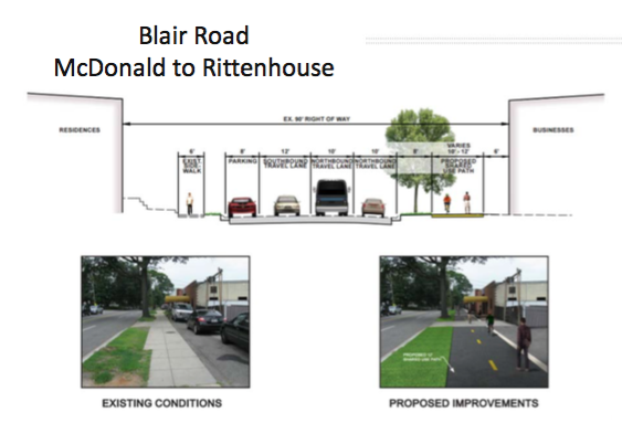
DDOT street layout on Blair Road with a rendering of the future shared trail
In fact, DDOT is already proposing an on-street trail along Blair Road further north, reducing Blair Road’s northbound lanes from two to one. At the meeting, DDOT planners shared that its traffic forecast estimates for removing one northbound lane on Blair Road will add 0.9 minutes of additional travel time during the peak PM travel period. One can imagine that removing the second northbound lane on Blair Road beginning at McDonald Place would not add more than 1 or 2 minutes at peak times for car trips, yet provide immense safety benefits for cyclists and pedestrians in this area.
DDOT’s current plan has the trail turning right onto Aspen Street before going north on Sandy Spring Road, which some residents say will add to traffic congestion. ANC subcommittee head Faith Wheeler said Aspen Street is already busy and about to get busier with all of the construction that is underway on the former Walter Reed site.
She and some residents implored DDOT to consider putting the trail on Van Buren Street, but DDOT noted that Sandy Spring Road is too narrow there for the trail to fit. Bicycling advocates countered that putting the trail closer to the new development at Walter Reed will encourage new residents to bike rather than take more trips by car. Building more bike infrastructure in order to relieve car congestion is a paradigm that seems to get lost in the discussion sometimes and this meeting was a good example of that problem.
A new MBT trail idea
At least one ANC Commissioner has her own concept for the MBT that could bring trail users closer to the Takoma Community Center, which has a pool, playgrounds, and a spray park. ANC4B Commissioner Tanya Topolewski, asked DDOT to explore whether the trail could or should be realigned along North Dakota Avenue and 3rd Street NW..
DDOT’s analysis says that North Dakota Avenue is too narrow for an on-street, protected trail, and would increase the number of intersection crossings (i.e. conflict points) from 3 to 10. But her innovation was acknowledged, and bike advocates asked DDOT to analyze building a MBT spur that would connect the MBT to Takoma’s amenities, but only after the MBT is actually built.
Commissioner Topolewski went so far to suggest a catchy name: the “Rec Loop.” DDOT would not comment on the feasibility of building the Rec Loop, but, given how long it’s taking to extend the MBT to Maryland, I wouldn’t place any bets it will be done before 2037.
ANC4B will be voting very soon to write a resolution in support or in opposition to the MBT alignment proposed by DDOT. Click here to contact ANC4B and register your support.
Maple Ridge Food Truck
ReplyDelete