A grocery store with a story
Back in 1981, the Takoma Park - Silver Spring Cooperative grocery store opened for business. According to a local historian, residents of Takoma Park and Silver Spring founded the Co-op as a vegetarian storefront in a community that shares the values first laid out by the cooperative tradition.
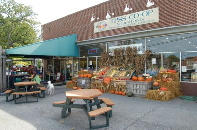
In 1998, the Co-op moved into a single-story building in Takoma Park at the confluence of two major roadways that share the road for one block: Carroll Avenue (MD-195) and Ethan Allen Avenue (MD-410).
These roads are both owned and controlled by the Maryland State Highway Administration, and the commercial area around this busy intersection is known as Takoma Junction. The Co-op is located about 7 blocks from the Takoma metrorail station and is serviced by multiple Metrobus and Ride On bus routes in a very walkable area of Takoma Park.
For the uninitiated, a cooperative is an autonomous association of persons united voluntarily to meet their common economic, social, and cultural needs and aspirations through a jointly owned and democratically controlled enterprise.
In this case, it’s selling groceries and, as of the autumn of 2015 beer and wine too. The Co-op expanded in the autumn of 2001 by opening a second location on Grubb Road in Silver Spring, which closed in November of 2013 due to underperformance.
According to their latest annual report, the Co-op has adopted the values and principles of the International Cooperative Alliance from 1995. It claims that it subscribes to ethical values of “honesty, social responsibility, and caring for others.”
While the Co-op sounds like a egalitarian or even aspiring socialist movement, it is in fact a for-profit corporation that grossed more than $3 million dollars in revenue last year and has over $1.4 million in cash reserves from sales. As an aside, I asked the Co-op’s Board of Directors for a list of all the Co-op’s shareholders and/or members, to which they responded they could not provide it to me “due to privacy and confidentiality issues.”
Development was planned before the Co-op arrived
In September of 1995, the City of Takoma Park paid $483,000 for two parcels of land near the Co-op. One of the parcels is a triangularly-shaped wooded area that is residentially zoned and slopes heavily towards Columbia Avenue. The other parcel is a paved parking lot that is commercially zoned and directly adjacent to the west of the Co-op. The development site has been recently expanded to the west by the developer who has a contract to purchase the Takoma Auto Clinic, which is closing. The full development site and its position relative to the Co-op is shown below.
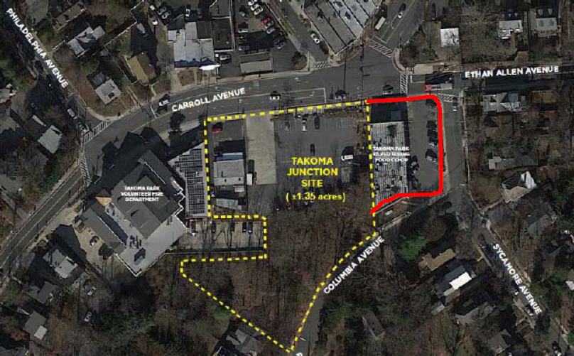
Satellite image of the Takoma Junction site from Google Maps with the development boundary in yellow and the TPSS Co-op’s leased building and parking lot in red.
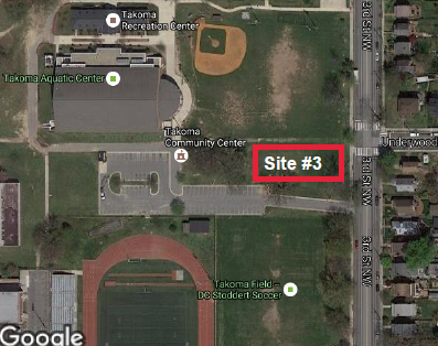
For a while now, the Co-op has rented some of the surface parking lot in order to facilitate deliveries that they claim cannot be scheduled and must be done with 18-wheeled trucks. According to one source, the Co-op’s deliveries cannot be fulfilled by these large trucks on their dedicated parking lot east of their store.
In January of 2014, Takoma Park issued a Request for Proposals to redevelop the surface parking lot in accordance with many recommendations made by the citizen-led Takoma Junction task force. According to the RFP, Takoma Park acquired these parcels of land “for purposes of stabilizing this small but important historic neighborhood commercial district and facilitating the redevelopment of the area in furtherance of the City’s master plan.”
The RFP’s guidance to developers encouraged them to create proposals that will “act as a stimulus to the commercial district and locally-owned, independent businesses; improve the aesthetic appeal of the district; and be contextually sensitive and environmentally sustainable.” The Co-op’s own market research showed there is demand for their expansion.
Despite not having any experience in development, the Co-op responded to the RFP with their own proposal to double their store size and offered Takoma Park $0 for the purchase of the Junction site. Not surprisingly, in September of 2014, when Takoma Park selected four finalists the Co-op was not among them. In April of 2015, Takoma Park selected Neighborhood Development Company to redevelop the Junction site.
The Co-op strikes back
Notwithstanding being passed over to develop the Junction site, the Co-op managed to marshall its most vocal patrons to lobby Takoma Park’s elected leaders to protect its business from the “encroaching” development. Passionate local residents and other patrons showed up in droves at many city council meetings and spoke about the Co-op’s special status and how it is part of the very fabric of Takoma Park.
And it worked. Takoma Park’s elected officials were swayed to intervene on behalf of the Co-op. After selecting NDC to redevelop the Junction site, Takoma Park crafted a development agreement that required NDC to negotiate in good-faith with the Co-op to expand its existing store somehow as part of the development and provide the Co-op with reasonable accommodation of certain parking and/or access areas located at the Junction site.
Even more significant, Takoma Park officials included a clause in the development agreement that prevents NDC from leasing any of the future Takoma Junction space to “another food co-operative (meaning a food distribution outlet organized as a co-operative) or grocery store (meaning a retail grocer or supermarket selling a large variety of food and household items).” This amounts to providing the Co-op with a government-sponsored monopoly at the Takoma Junction as there is no other commercial space large enough to accommodate a grocery store.
Over the course of many months NDC and the Co-op tried to negotiate a Letter of Intent over the Co-op’s expansion into the new development. The Co-op publicly stated that they wanted to expand their store, but they signed a 20-year lease in 2015 for their current building that not only needs major upgrades but does not provide any expansion opportunities. Of note, the City of Takoma Park is retaining ownership of the Junction site and is providing NDC with a 99-year ground lease.
Even with Takoma Park officials providing the Co-op with additional time to get a LOI in place, NDC and the Co-op could not come to an agreement. The major sticking point appears to be that the Co-op’s rent in their current building ($28 per square foot) is much lower than what NDC is asking ($45 per square foot) if the Co-op wants to expand into newly-built commercial space at the Junction site.
What’s noteworthy here is that the Co-op itself identified the desirability of moving into a new building back in 2011. Using the data from the Old Takoma Business Association’s recent area rent analysis, it appears that the Co-op’s current rent is the lowest in the Junction area and NDC’s proposed rent is within the normal range for new construction.
In addition to their demand for a custom-built, new construction addition tied into its existing building at (or near their) below-market rent, the Co-op included other questionable demands from NDC, such as exclusive, non-compete agreements within 50 feet of the Co-op for coffee shops, wine/liquor stores, and, oddly, educational facilities. As stated in a letter from NDC to the Co-op, “these exclusions would materially increase the value of [the Co-op] while lowering the value of the rest of the project.” Unsurprisingly, the parties were unable to come to terms.
Stall, delay and make it go away
After the failed LOI negotiations between NDC and the Co-op, Takoma Park passed a resolution that permitted NDC to secure a new anchor tenant, so long as it is not another food cooperative or grocery store that would compete with the Co-op. NDC was also cleared to begin its required community outreach with the assistance of a citizen advisory committee. NDC held four community meetings and conducted two surveys to gather input. Disclosure: I served on this committee.
After almost four years since Takoma Park issued its initial RFP for the Junction site, many local residents have attended numerous public meetings, listened to countless hours of testimony and read hundreds of neighborhood emails from Co-op patrons and advocates that have tried to derail this project. Thanks to an intrepid group of neighbors that want to revitalize the Junction, Takoma Park officials have stayed the course in a deliberate, but cautious manner.
What’s just plain maddening is that it has taken Takoma Park so long to get to this point, and even though the timeline shows the groundbreaking in May of 2019, city officials said it is likely to be pushed back again! For perspective, the Empire State building was built in just over a year.
If the Co-op gets its way, this timeline will almost certainly be extended again. All this effort for a grocery store that some people have observed is very expensive and does not serve the middle or lower socioeconomic classes.
In late September 2017, NDC, partnering with Streetsense, finally presented its concept plan for the Junction site. The concept is a mixed-use development that provides 72 underground parking spaces, along with three levels of retail, office and community space as shown in the concept drawing below.
Whatever one’s view is of the design, NDC’s concept is transformative and could turn an otherwise neglected commercial district into another third-place for the Takoma Park community (with Old Town and the Takoma/Langley Crossroads being others).
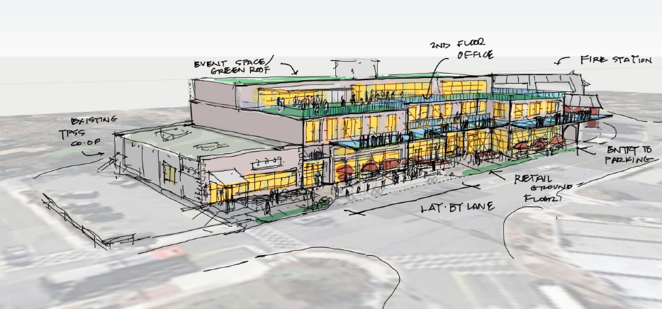
NDC’s concept plan for the Junction site. Image from NDC and Streetsense.
But now that NDC has presented its concept plan, the Co-op has doubled-down on their “special status” and encouraged more anti-development rhetoric. You can read their latest rally cry to their 9,000+ members here. Below I will address the Co-op's points against NDC's concept plan.
Festivus (i.e. airing of the Co-op’s grievances)
We have reviewed NDC’s concept plan as presented to the Council on September 27, and we believe it could seriously harm the operation of our 36-year-old food market. … As submitted, your Co-op leadership believes the development gambles with the future of the Co-op and is a danger to the safety and character of our neighborhood in Central Takoma Park.
The Co-op first claims that NDC’s concept plan threatens its survival, despite the fact that Takoma Park officials gave the Co-op a 99-year monopoly to sell groceries at the Junction site. What other local businesses may be wondering is if Takoma Park officials are also going to provide them similar protections against competition? Without this protection, NDC could very likely convince one of the Co-op’s competitors (e.g. Yes! Organic, Mom’s Organic Market) to become the anchor tenant at the Junction site.
Some people say that it’s ok for Takoma Park to provide this protection to the Co-op from competition because it’s a local business that provides jobs, but the data shows that Republic restaurant and a few other local businesses employ more people than the Co-op. I think the Co-op should be humbly grateful that it’s been provided with this tremendous gift at taxpayer expense - but instead it has the audacity to ask for even more special treatment.
In addition, by arguing that NDC’s concept plan development is a danger to the “safety and character” of the neighborhood, the Co-op has aligned itself with anti-development opponents, who are alive and well in Takoma Park. It’s ironic for sure, but not unprecedented, to see a private, for-profit business use this strategy. Let’s hope that Takoma Park officials recognize this statement for what it is - a typical NIMBY argument.
The latest design by NDC is too large for the available space. Although earlier discussions centered on an environmentally friendly, low-density building with green space, the new version is not that.
I find it odd that the Co-op is making judgments about the concept plan after it chose not to be part of the development, but I’ll analyze this assertion nonetheless. It’s true that NDC’s prior rendering was slightly smaller than their proposed concept, but that concept isn’t all that different as shown below.
What the Co-op also fails to mention is that the prior concept was based on NDC’s offer to build the Co-op an entirely new, larger space and to either acquire or have the Co-op sublease their current building. In other words, the Co-op is comparing “organic” apples and “conventional” oranges here.
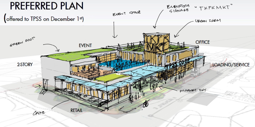
Previous rendering of Junction development site. Image from NDC.
As explained in Takoma Park’s FAQ handout on the Junction site, NDC’s concept plan is only 3,000 square feet or 6.4% larger; moreover, let’s not forget that NDC’s current concept is … well … a concept. Anyone who works in development knows that concepts are often changed at least a few times before shovels start digging.
Takoma Park officials have already indicated that they will likely ask NDC to refine their concept, but instead of being patient and letting city officials do their job the Co-op sent alarmist signals to its members and they came out swinging.
In addition, according to OTBA’s recent market analysis, gross demand for commercial space on its main street corridor in 2017 is 195,000 square feet and there is it currently 115,000 available square feet. By 2022, OTBA predicts that total gross demand for commercial space on its main street corridor is estimated to be 211,000 square feet.
On the question of massing, a 3-story building is hardly a high-density one for a development less than a mile from a Metrorail station and arguments against it sound more like a case of “height-itis.” Plus NDC’s proposed concept provides a rooftop community green space that is set back from the second story.
NDC's concept is not out of scale with the neighborhood, as the nearby fire station, apartment buildings, and many houses in Takoma Park are also 3-stories. Let’s hope that Takoma Park officials are open-minded and creative about a third-floor and do not fall victim to the narrow viewpoints of a small, vocal minority.
The latest proposal does not leave adequate room for the big-truck deliveries that are necessary each morning to supply our grocery store (and future tenants) and keep it operating, nor for proper handling of our (and future tenants’) waste and recycling. Pushing these trucks into the street to wait their turn at a cramped loading facility will impinge on our business and upon residential neighbors and create traffic bottlenecks.
To me this is what the Co-op is fighting most. The Co-op has had the luxury of using the adjacent parking lot for their deliveries since 1998. The Co-op claims that it is not a normal grocery store in that it cannot control the arrival and/or size of their delivery trucks and that most of its deliveries is with 18-wheelers. The Co-op currently rents much of the surface parking lot so that these 18-wheelers can drive head-first into the parking lot and do a U-turn to facilitate deliveries, which takes up a lot of space. This ties into their next concern.
NDC’s proposed lay-by on Carroll Avenue is a serious safety concern, situated adjacent to pedestrian and biking lanes, a bus stop, emergency lanes for fire trucks and trash pickup, and near cross walks at an already too-busy intersection.
Since the Co-op has decided against expanding into the Junction site, NDC’s development agreement with Takoma Park only requires that it “provide reasonable accommodation to the Co-op’s operation of its business in the Co-op Existing Premises, which accommodation shall include access for loading of deliveries and Co-op customer parking, provided the Co-op is operating in the Co-op Existing Premises.”
Lay-bys are a fairly common urban development tool used in many cities to provide parking space for buses and other large delivery vehicles. Below is a sketch from NDC that shows how the lay-by will look in context to the Junction site.
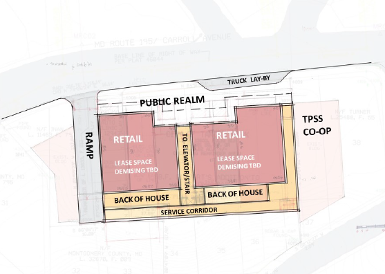
Sketch of ground floor plan for Junction site showing the “lay-by”. Image from NDC.
I will agree that the lay-by concept is less than ideal. NDC’s current concept shows restaurants and cafes along Carroll Avenue and -- while most of the Co-op deliveries are in the early dawn hours -- nobody wants to be sitting outside for dinner or having a drink with friends when a loud 18-wheeled truck shows up and has to unload boxes of produce for 1-2 hours.
As an aside, I think any restaurants on Carroll Avenue should be located closer to the ramp in NDC’s concept and away from the lay-by, or why not move all dining al fresco on the 2nd or 3rd floors away from the noise and smell of car exhaust?
My own reading of the development agreement makes me believe that NDC doesn’t even have to provide the Co-op with the lay-by and could instead require the Co-op to figure out deliveries on its own parking lot or any of the three sides of its building over which it exercises control.
The Co-op doesn’t consider that while the lay-by concept is being done for their benefit it’s an eyesore and traffic headache being done solely for their business operation. It’s reprehensible that the Co-op is playing the “safety” card in an effort to convince its members to lobby Takoma Park officials on its behalf - and it’s another example of their rent-seeking behavior.
There is too little parking planned for the site – forcing our customers and those of businesses at the new building to look for parking in adjacent residential and business areas. Frankly, we fear that many of our customers will give up on parking and go elsewhere to shop. The proposed 72 spaces are simply not enough.
According to the original RFP, the current surface parking lot has 56 spaces, of which the Co-op currently rents 16 spaces. I also count 16 spaces on the Co-op’s own parking lot to the east of their building. NDC’s concept plan replaces the current 56 parking spaces with 72 underground ones, and despite no expansion plans the Co-op has requested to reserve 25 of these parking spots (for an increase of 9 spaces). NDC's concept adds 14,600 square feet of retail space, 19,800 square feet of office space, and 9,500 square feet of community/event space on the third floor.
The task force report and the RFP make it clear that Takoma Park wants the Junction site to be a neighborhood gathering space that provides people with options as to how they arrive at the Junction site (i.e. walk, bike or drive). It’s the same reason that Takoma Park located a Capital Bikeshare station at the Junction (despite being a terrifying place to ride on the road - something this project could rectify by simply removing one driving lane and replacing it with bike lanes).
It’s true that some patrons will avoid shopping at the Co-op if it’s hard to find parking, but the Co-op is a niche grocery store with less than 5,500 square feet and therefore already not competing with normal grocery stores that lure shoppers with the promise of easy, free parking.
As for traffic, a study will help figure out how much more traffic will result although many experts find predictions to be dubious at best. And so what if a traffic study does predict an increase. As noted by former Montgomery County planning director Rollin Stanley, “the best places to visit have the worst traffic.”
Ask Takoma Park to move forward
When Takoma Park made the decision to develop the Junction site, the Co-op claimed that it wanted to expand and be a part of the project. When the Co-op wasn’t chosen to develop the site it claimed it still wanted to expand, but it was unwilling to either break its current lease and move into the new development or pay a higher rent to connect its current building with the new development.
Now that the Co-op is stuck in its current building with no plans to expand, it is relying once again on its special status and using its weight in the community to convince Takoma Park officials to delay and/or cancel the Takoma Junction project altogether. To me, this does not sound like an organization that values “honesty, social responsibility, and caring for others.”
If elected officials decide to delay or cancel the Junction site it may cause a ripple effect on any future developer to pause when considering to pursue development in Takoma Park, especially in the Takoma/Langley “Crossroads” of New Hampshire Avenue and University Boulevard, a less-affluent part of Takoma Park.
NDC’s concept plan isn’t perfect, but it’s a transformative vision that represents the real compromises that Takoma Park officials made when they chose to protect the Co-op’s business needs. The sad irony here is that a larger, more robust development will benefit the Co-op’s business by bringing more foot-traffic to its doors and the Co-op has instead chosen to see the glass as “half-empty.”
On October 25th, Takoma Park’s officials will be voting on NDC’s concept plan. If you want them to see the glass as “half-full” and move forward with the Junction site, you can tell them to vote “Yes” by clicking here.